Plato literarily develops geometry and vice versa. In other words, he puts maths in words. The description is not easy, but the logic is irresistible. The shape given initially is of an isosceles triangle of which the centre of its base line lies on the sacred Island of Atlantis and also marks an defining point on the system of wheels that Plato reports as being “The Centre of All”.
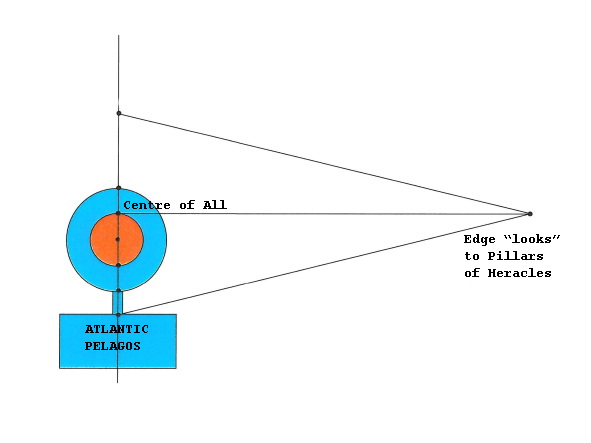
Consequently, logically, because of Plato’s descriptions, the triangle and the semicircle must be mirror imaged. Thus and for the first time in history, is derived the following design that illustrates the shape of the Island of Atlantis.
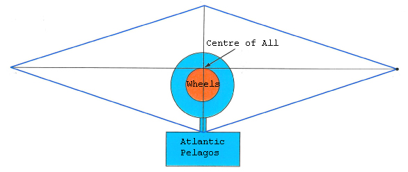
After the mandatory doubling of the above design, a rhombus was formed whose relation of width to height is 1:4. Using algebra and geometry, the altitude and base length of the isosceles triangle can be calculated. The exact position of the system of wheels within the rhombus was also calculated and found after difficult but accurate analysis which is laid out step-by-step in the book “The Apocalypse* of a Myth”.
All the shapes outlined in this site, are considered to be geometrics that are highly unlikely to be found occurring naturally. And yet, they have been identified, in nature, in the indicated position and with their estimated dimensions (with divergences of 1 – 4% !).
The land feature pictured below, was found in the way worked out. It is a plateau in Mauritania where, at the indicated location are the indicated system of wheels in their indicated dimensions!
Impressively, Plato describes each of the 5 wheels as having distinctive but ‘extraordinary’ features. These ALL exist at Richat; without exception! Equally impressive, is that although many scientific expeditions have gone there for research, none noticed to report on these unusual characteristics (or perhaps did not consider them worthy of comment). For example, should it not have drawn someone’s attention as peculiar that the rings are more or less circular whereas their centre is … square? Indeed these unique features are even more reason to verify the accord between the translations and the place, while further bearing out the preciseness of Plato’s depictions.
This natural landform has recently been scientifically explained by a Canadian university team. It is extremely old. Because of its enormous spread (of the whole system), as provided for by the texts, it is unobservable from the ground -nor even by airplane- and there is no record (apart from Plato’s) of anybody knowing of its existence until the first American Astronauts saw the concentric wheel system from space and dubbed it the Eye of Africa! That was in 1964**. Its official name is Guelb et Richat and is on the plateau (depicts the island) of ATAR which is surrounded by relatively featureless expanses of desert. It is clearly discernable even today and it can be easily understood as to why it was an island.

* see Lexical Disambiguation of ‘Apocalypse’
** a)The present writer had no clue as to the existence of this place until 2007, when he was ‘transported’ there by Plato… Since then, he has flown, driven and walked over it several times, taking measurements in substantiation.
b) Interestingly, a reader (N. Kaloudis – The translator of the book in English) made the observation that the day on which Richat was first observed, overlaps with the time given by Edgar Cayce as to when Atlantis would be found… (!?) (This is the only one bizar reference of this site)